- Home
- Critical Decade
- HI Climate Action
- HI Commission
- HI Resources
- HI Equity
- HI Events
Rising Sea Level
What is Sea Level Rise?
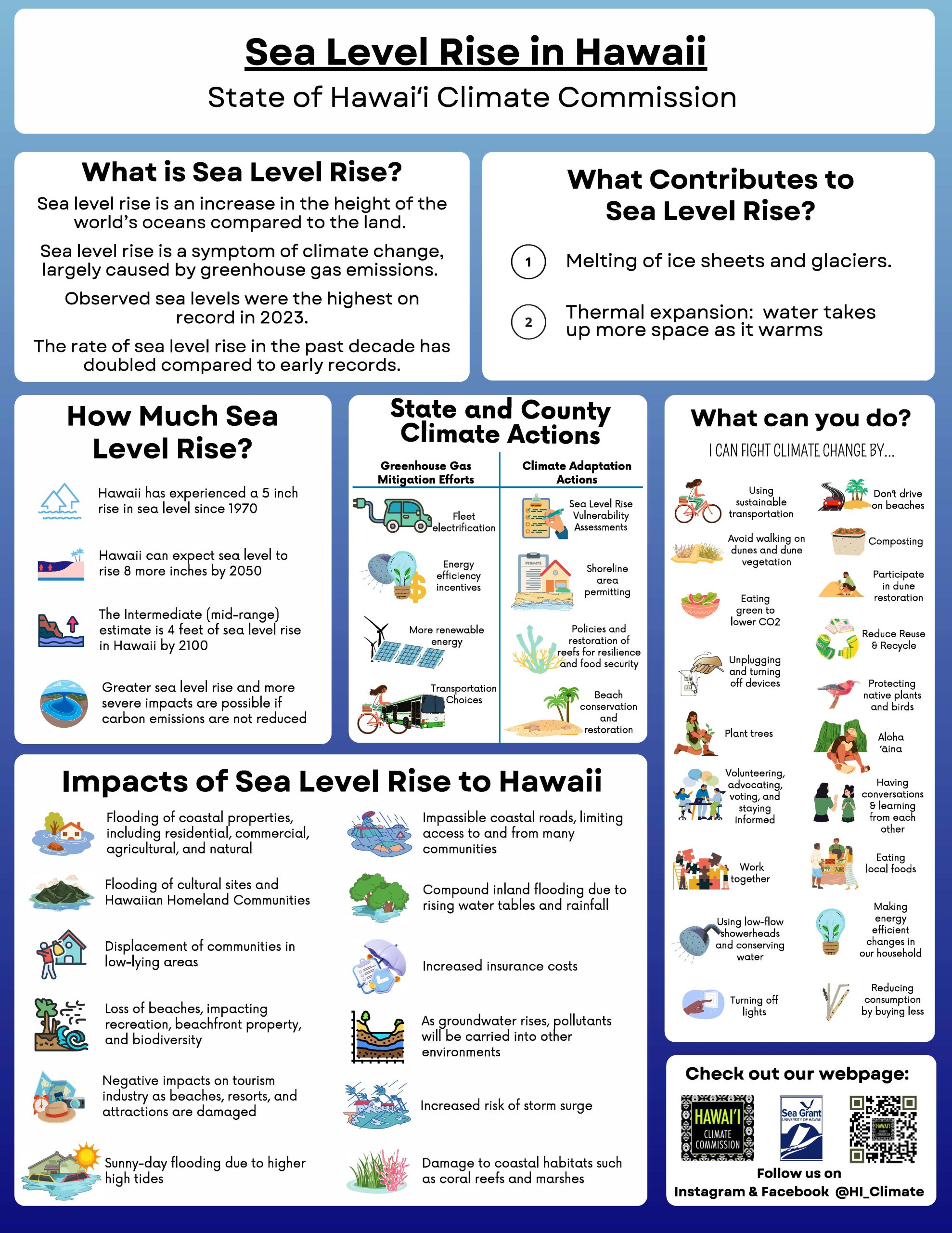
Local sea level rise means that the level of the ocean is rising relative to the land next to it. In Hawaiʻi sea level rise means the loss of our beaches, homes and critical infrastructure such as roads. As the sea level increases relative to the land, we can observe that our dry beaches are disappearing with former areas of dry sand now being chronically under water. This is a symptom of climate change.
The two key contributors to sea level rise are:
1. Melting ice sheets and glaciers
2. Thermal expansion: water takes up more space as it warms
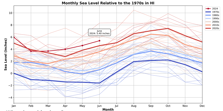
Sea level in Hawaiʻi has already risen 5 inches since 1970
The ice caps are melting, sea levels are already rising, and Hawai‘i is feeling the impacts. Sea level in Hawaiʻi has already risen 5 inches since 1970. Some areas of the islands have seen even more dramatic sea level rise increases such as the sea level around Hilo Bay which has risen by 10 inches since 1950. While the sea level naturally fluctuates year to year and throughout the year due to natural variation in tides, seasons and other factors such as El Nino, the overall increase seen in the sea level seen since the 1970s is driven primarily by human caused climate change.
High tide flooding has increased from 2 days a year in the 1970s to 40 days a year in the 2010s
Minor flooding has become the new normal for coastal communities. As sea level rises, the gap between the ocean and coastal infrastructure decreases meaning we are reaching the flooding threshold more often. This has already increased the frequency and reach of coastal floods. Between 1970 and 1980, Hawaiʻi saw only 2 minor high tide flood days. Between 2010 and 2020, we experienced 40. These floods, which causes disruptions like flooded roads, were fully attributed to climate change and sea level rise. Today, Hawai‘i has 66,000 people regularly at risk from coastal flooding. In Kailua for example, 50% of the population resides below expected flood zones.
Hawaiʻi can expect 8 in of sea level rise by 2050 and 3.5 ft by 2100*
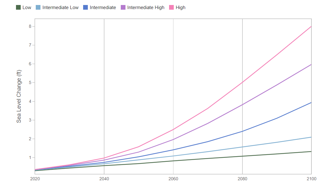
As global warming continues, sea level rise will accelerate. In the next 30 years, the sea level is expected to rise 8 inches when in the past 30 years it only rose 3.5 inches. Under an intermediate scenario, this means Hawaiʻi can expect 8 inches of sea level rise by 2050 and 3.5 feet by 2100. Depending on our future emissions, Hawai’i could experience up to 8 feet of sea level rise by the end of the century as a potential worst case scenario. This sea level rise will further exacerbate chronic high tide flooding and coastal erosion as higher water levels added to the natural rise and fall of the ocean will cause water to flood the land more often.
* Relative to the 2020 sea level
Sea level rise cannot be fully prevented. Our historic emissions will cause the sea level to rise for many years even if we were to completely eliminate emissions today. However, by taking efforts to reduce our emissions, we can mitigate sea level rise and avoid a worst case scenario. Hawaiʻi is committed to net negative greenhouse gas emissions by 2045. By taking actions such as transitioning to renewable energy and electric vehicles, expanding transit, biking and pedestrian access, and improving energy efficiency, Hawaiʻi can help limit sea level rise.
hawaiʻi can expect 150 high tide flood days per year by 2050.
The rapid increases in flooding Hawaiʻi’s coastal areas have seen will continue and worsen over time. By 2050 under the intermediate scenario, Hawaiʻi can expect 150 high tide flood days, per location, per year. Beyond 2050, we can expect areas that were formerly dry beaches to be chronically underwater.
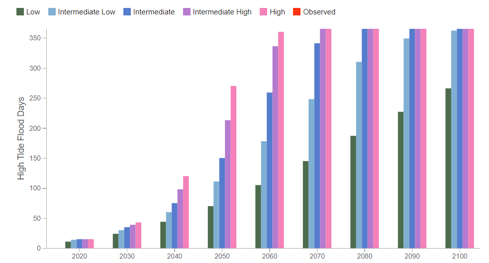
Mitigating sea level rise by limiting our greenhouse gas emissions will help mitigate high tide flooding. In addition, Hawaiʻi is taking actions to adapt to high tide flooding and limit the impacts on our communities. Each county has developed a hazard mitigation plan which includes the impacts of sea level rise and coastal erosion.
70% of beaches and 4,000 structures in the state are threatened.
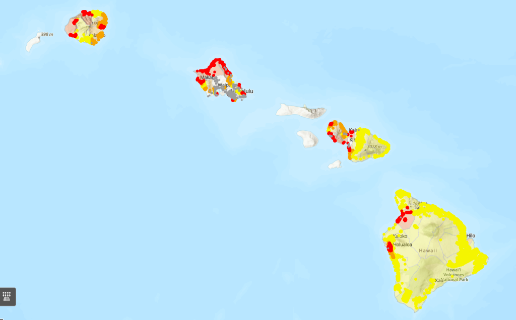
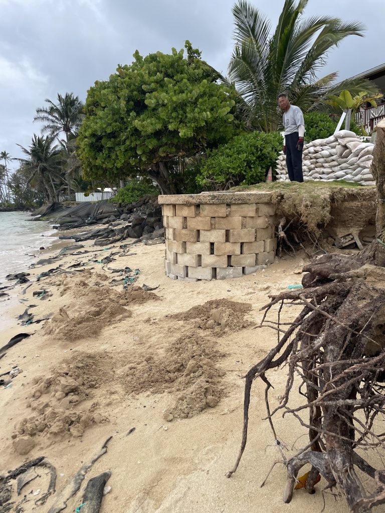
Nearshore environments throughout our state are at risk of coastal erosion. 13 miles of beaches around the state are already gone due to shoreline hardening structures such as sea walls, including 10% of O‘ahu’s beaches. 70% of beaches around the state are currently threatened. This erosion also threatens to impact thousands of homes built near the coastline. Collapse of these structures can pose serious threats to nearshore ecosystems. Maps of historic coastal erosion can be found on the Hawaiʻi Climate Data Portal’s Coastal Erosion tool.
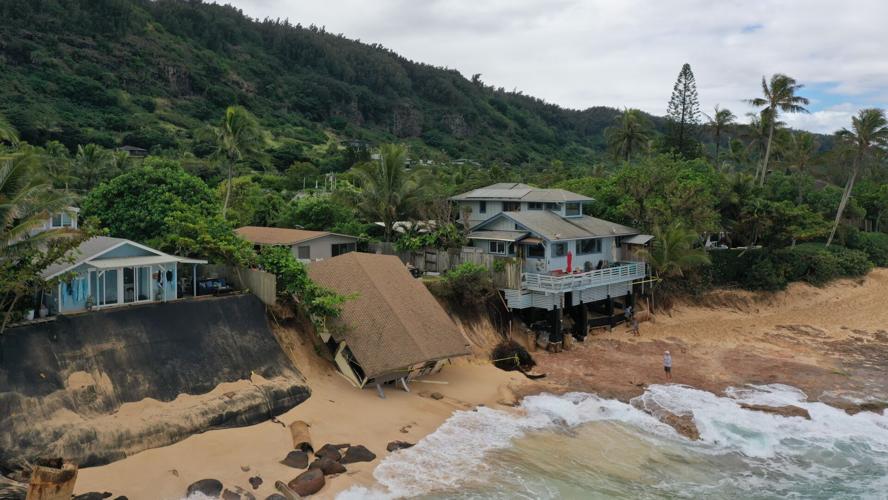
MITIGATING COASTAL IMPACTS
The Coastal Zone Management Act was established to manage and protect the use and development of our coastlines. The Coastal Zone Management Program acknowledges two major methods of managing coastal erosion. Hardening structures such as seawalls, groins and revetments physically protect structures near the shoreline however they lead to further erosion of the sand. Hardening structures have contributed to the complete loss of 13 miles of Hawaiʻi’s sand beaches. A more effective method of managing coastal erosion is recognizing the dynamic nature of the shoreline and restoring the natural processes. Through zoning, managed retreat and the restoration of natural dune ecosystems, coastal erosion can be mitigated. The Office of Conservation and Coastal Lands has begun a demonstration project at Punaluʻu Beach Park, applying nature-based solutions to protect critical infrastructure, ecological resources and restoring the beach park to serve local communities.
high tide flooding is impacting our inland infrastructure
Flooding is worsening further and further inland where seawater will flow backwards through storm drains, and upwards by coastal groundwater emergence – leading to pools of dirty, contaminated brackish water where we live. In Mapunapuna industrial area on O‘ahu, the last decade has seen a dramatic increase in the number of flood days, so much so that the area is now considered to be in a state of chronic flooding. This hurts businesses, damages vehicles and infrastructure, and is devastating to our coastal ecosystem. The impacts of sea level rise are further exacerbated in areas that were historically wetlands such as in Mapunapuna and other areas like Waikiki and the Keehi interchange. As the infill settles land sinks making it more prone to flooding.
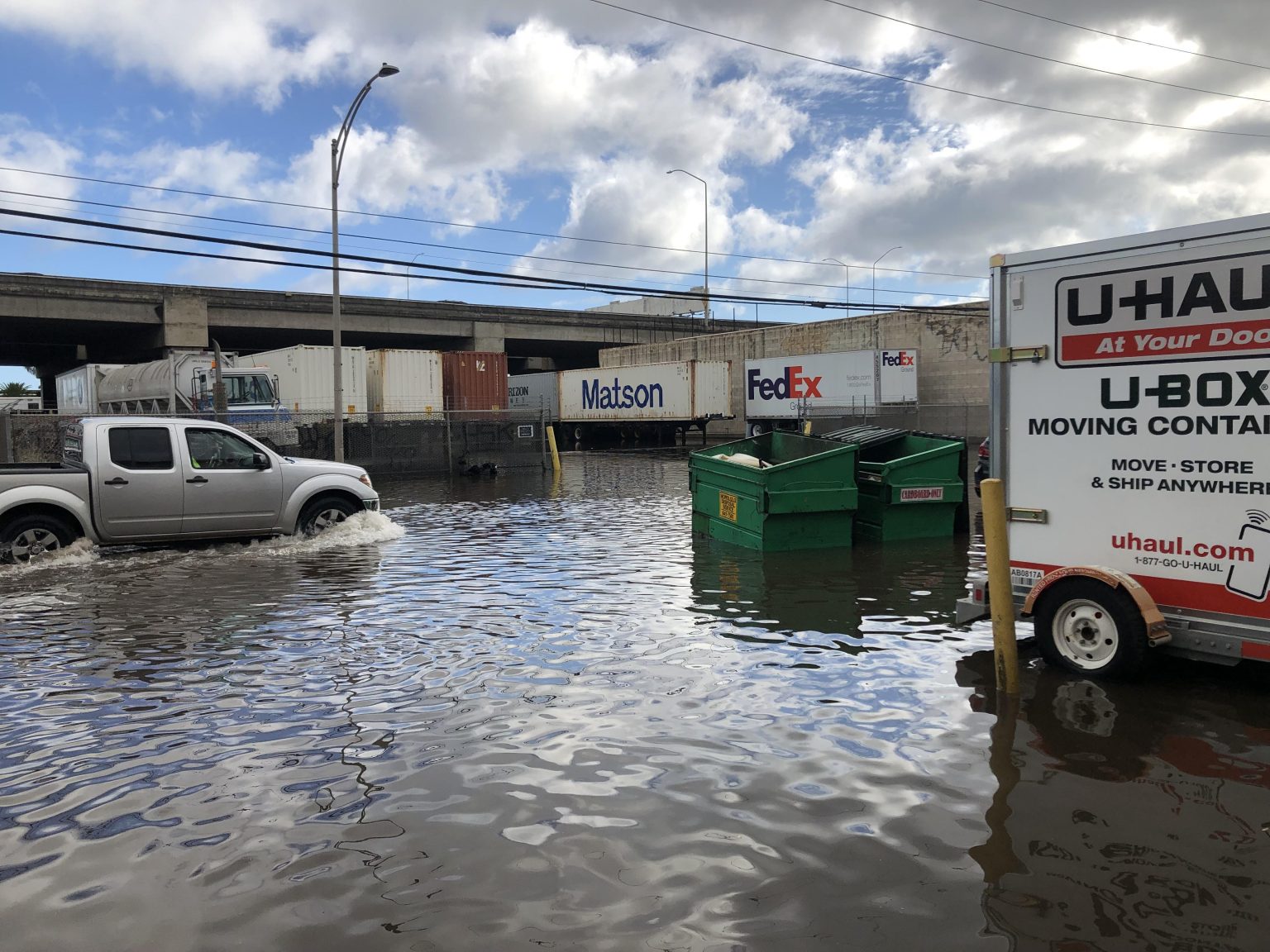
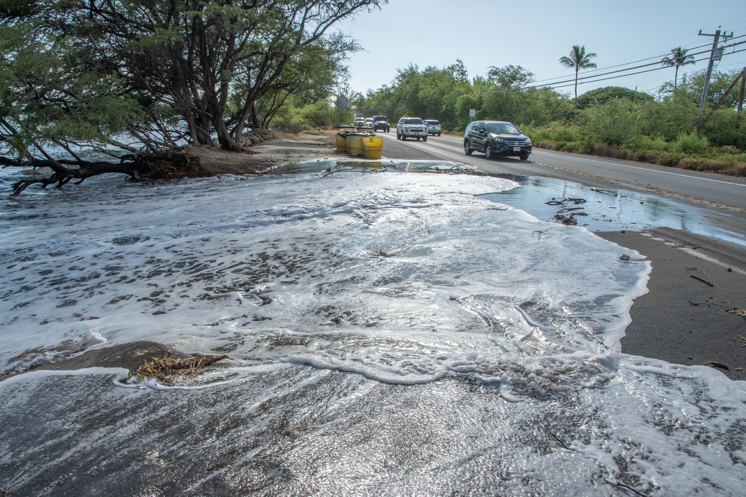
MORE FREQUENT HIGH TIDE FLOODING IS THREATENING OUR CITIES. The frequency of yearly floods in Honolulu has spiked, and you don’t have to live on the coast to see the evidence. More flooding means increased damage to roads and buildings and overwhelmed drainage systems. In Hawai‘i, where we often have only one road in and out of our communities, road closures because of flooding and erosion are a big problem.
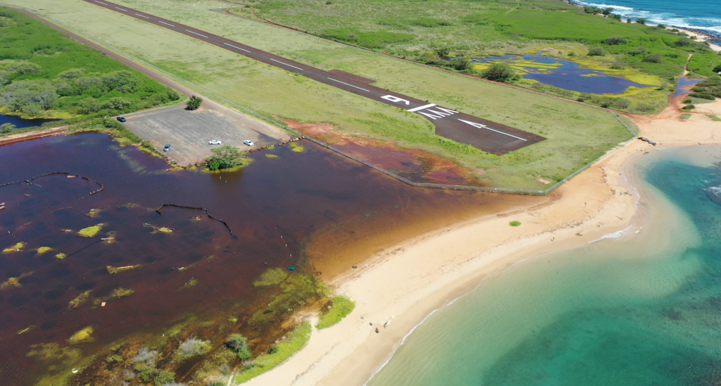
TRADITIONAL AND CULTURAL PRACTICIES ARE AFFECTED. Sea level rise affects traditional and customary practices, including fishpond maintenance, cultivation of salt, and gathering from the nearshore fisheries. This can have a negative effect on people’s spiritual and mental health.
53 million gallons of untreated sewage are released into Hawaiʻi’s Waterways each day.
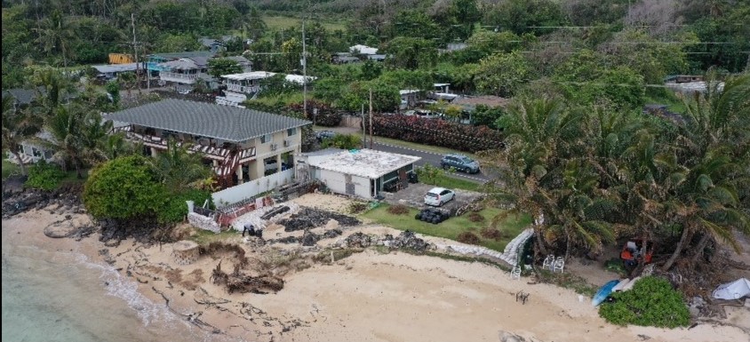
Many of Hawaiʻi’s cesspools are threatened by sea level rise and coastal erosion. Each day about 53 million gallons of untreated sewage are released into Hawaiʻi’s waterways. As the water table rises due to sea level rise, more waste from cesspools will enter our waterways, flowing into the ocean and flooding our inland communities. Cesspools built too close to the coastline are at risk of flowing directly into the ocean as the surrounding sand erodes. Waste flowing into the water is a threat to both public health and ecosystem health as is harms our coral reefs. Visit
Future chronic flooding will make 25,800 acres of land unusable
Chronic flooding will lead to an additional 25,800 acres of land becoming unusable, and 6,500 structures are projected to be at risk due to sea level rise. About 550 cultural sites, 38 miles of major roads, and at least $19 billion in assets will be exposed to chronic flooding. Sea level rise is particularly threatening to Waikīkī and military infrastructure around Pearl Harbor. Sea level rise is an existential threat to Hawaiʻi’s food security, water supply, economy, cultural heritage, and overall habitability.
Statewide efforts at mitigation and adaptation are necessary in the face of rising sea levels. This includes changes to building design, community relocation, permitting changes, and protection of coastal environments. To see how your community will be impacted in different sea level rise situations, we encourage you to use the Hawaiʻi Climate Data Portal’s sea level rise visualization tool.
Data and statistics from the US Sea Level Change Taskforce reflect the data collected by the National Oceanic and Atmospheric Administration.
Monthly Relative Sea Level:
Tide Gauge: https://tidesandcurrents.noaa.gov/products.html
Satellite Altimetry: https://podaac.jpl.nasa.gov/NASA-SSH?tab=background§ions=about%2Bresources
Sea Level Scenarios:
2022 Interagency Technical Report: https://oceanservice.noaa.gov/hazards/sealevelrise/noaa-nos-techrpt01-global-regional-SLR-scenarios-US.pdf
Tidal Flooding:
Tide Gauge: https://tidesandcurrents.noaa.gov/products.html

